Skitouring tips north of Dolomites
- Jan 24, 2023
- 3 min read
The northeast of historical land South Tyrol consists of several valleys around the town of Bruneck (Brunico). The third largest city in South Tyrol (after Brixen and Bolzano) lies on the border of the Dolomites and other mountain ranges of the Eastern Alps
The Villgraten mountains are a not very well-known name. They were named after the Villgratental valley, which is located in the Austrian part of its territory. They were formerly also called Defereggengebirge, after the valley forming their northern border. A smaller part of the Vikgraten Mountains lies on the territory of Italy, where they are separated from the Dolomites by the valley of the Rienz River (Bruneck, Toblach).
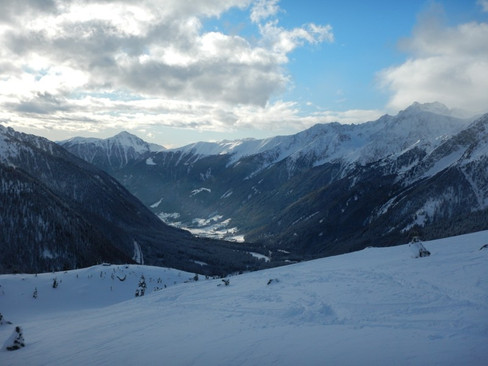
Thanks to its natural beauty and relatively good accessibility, it is a popular location for hiking and skiing tours. A famous resort on the other side of the river is called Kronplatz (Plan de Corones). Eastern half of the 2275 meter high mountain is surrounded by a handful of pistes of all difficulties. The largest bell in the Alps, Concordia 2000, is located at the top, and the Giro d'Italia race came here several times. Of course, skitouring enthusiasts will also enjoy here, but let’s check some worthy tours a little further to the north.


Towards the Italian-Austrian border stretches the Antholztal valley (Anteselva), which climbs up to the the Staller Sattel pass (2052 m). In winter, you can ski along the road winding from Lago di Anteselva. And if you drive here in the summer, itš goot to know that the traffic is allowed for only fifteen minutes per hour in each direction.
Several skitouring tours start from the lake Obersee, just beyond the Austrian border. One of the most beautiful is the ascent to the 2818 meter high Rote Wand. Whole tour climbs at relatively gentle slopes through the valleys between the two ridges stretching from the summit. After the northern rodge, we will reach the simple summit cross. If there is little snow, we will also see a round board with a description of the panorama. It is less than 900 meters from the parking lot below the lake.


We can take two other similarly exposed skitours on Hinterbergkofel (2727 m) and Innerrodelgungge (2729 m). Both climb the northern slopes and reach the border peaks from the Austrian side.
On the other side of the lake, we can go to the slightly steeper Almerhorn (2985 m). Even with the cross, it won't reach the title of three-thousander, but it is already a more demanding tour with a rocky peak. And if you are still not tired, add the nearby Große Mandl (2818 m) as a bonus.


Further inspiration awaits in the next valley, further south. Valle di Casies (Gsiestal) is, besides other attractivities, the scene of the famous cross-country ski marathon. Kilometers of tracks stretch all the way to Santa Maddalena, where most ski-tours start.
Head to the north to the Hochkreuzspitze (2739 m). At the upper end of the sledge run (a path that can be followed or, depending on the conditions, can be avoided through the side valley) have a refreshing break in the Uwald Alm pub. Continue with a steeper climb to Spielbuhel / Monte Piano (2272 m) and further along the flat ridge, from which we traverse under the pass of Pfoischarte (2608 m). We are already at the border line and we head northwest passing the Mittlerhochkreuz (2718 m) to the top of the Hochkreuzspitze.


The views are absolutely amazing. Hohe Tauern in the north with the highest Grossglockner clesrky visible and Gross Venediger more on the left. On the other side admire the panorama of the jagged Dolomites. We have the famous Tre Cime in a good angle.


The eastern slopes offer a tour to the Hoher Mann (2593 m), which starts from the ski-slope in Santa Maddalena.
On the other side, head west to the Rotlahner (2743 m) and find yurselves again at the border, which, according to the terrain, forms a semi-arc around Santa Maddalena. Ascend the valley of the Koflerbach stream to the edge of the forest, where views of the white slopes with several cottages open up. From here we have several options to the reach saddle and then follow the western ridge to the summit.


And if the weather or snow conditions are not good, you can go cross-country skiing for kilometres along the valley and more all the way to Toblach and beyond.


Comments