Kaunertal Glacier Road – Cycling into the World of Eternal Ice
- Sep 25, 2025
- 3 min read
Hidden in the far western corner of Tyrol, the Kaunertal Glacier Road is one of the highest and most spectacular paved climbs in Austria. Starting from the Inn Valley, it winds through a long glacial valley, past the turquoise Gepatsch Reservoir, and finishes high above the treeline at the edge of the glacier. For road cyclists and mountain lovers alike, it’s a ride into the world of ice and rock—remote, quiet, and breathtaking.

09/2025
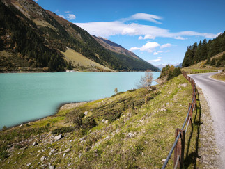
A glacial valley with a dam and a panoramic road

The Kaunertal Valley begins near the village of Kauns and stretches south along the Fagge River, which flows from beneath the Gepatschferner glacier before joining the Inn. In 1964, engineers built the Gepatsch Reservoir, a six-kilometer lake surrounded by steep slopes. Its hydroelectric plant lies in the neighboring valley near Prutz, connected by a 14-kilometer pressure pipeline that drops more than 800 meters. The rockfill dam itself is 600 meters long and 153 meters high.
The surrounding Ötztal Alps hold more than 350 km² of glaciers—the most heavily glaciated range in the Eastern Alps. The Gepatschferner, 9.5 km long, is one of the largest. To the east lies the Pitztal Valley, another mecca for glacier skiing and backcountry touring.


The Kaunertal Glacier Road, completed in 1982, is a toll road from the village of Feichten. Over 26 kilometers it climbs 1,450 vertical meters, crossing 29 hairpin bends. After an easy start, the road flattens along the reservoir before the final steep ascent, where gradients hover around 9%.
From the Inn River to the foot of Weißseespitze

Warm autumn weather calls for long climbs. After yesterday’s ride up from Sölden (Ötztaler Glacier Road), we go again—this time from the Inn River in Prutz (870 m). The climb totals nearly 2,000 meters of elevation gain over 38 kilometers.
The road follows the river through a narrow valley, diving into tunnels before reemerging on sunny meadows dotted with hamlets. Past Feichten, cyclists ride free through the toll gate—drivers pay a hefty fee for the privilege of continuing.
The first switchbacks appear beneath the massive dam wall. Starting with turn number 29, we reach 26 before the turquoise waters of the Gepatsch Reservoir come into view. The visitor center has just closed for the season. Due to ongoing landslide repairs, the eastern lakeshore offers the smoother surface, though “smooth” is relative—the road surface bears the scars of harsh alpine winters. But the views, both forward and back, make up for every bump.
.


One switchback after another
Beyond the lake, the gradient bites harder. We pass the historic Gepatschhaus hut, its wooden chapel and bell tower standing proud in the alpine silence. After another tight gorge and a few more switchbacks comes a straight stretch and the lower station of the first ski lift. At turn number 10 we reach the Ochsenalm restaurant—closed outside of ski season.
With the Ochsenalmbahn lift on our left, we climb toward Weißsee Lake, the penultimate stop of the local bus line. The final one, Kaunertal Falginjochbahn, is the highest public bus stop in Europe—and our goal. A few hundred meters of climbing remain. The road winds through rugged terrain used as ski slopes in winter. We pedal all the way to 2,750 m, reaching the Gletscherrestaurant Weißsee and the upper lift station. That’s the end of the road.
Just before closing time, we manage to charm our way into a quick coffee—glacier-priced, naturally—but have to drink it outside.
Above us towers the north face of Weißseespitze (3,498 m). Cable cars lead toward the Falginjoch (3,115 m) and Karlesjoch (3,105 m) saddles. The ridge between them marks the Austrian–Italian border, beyond which stretches the Vallelunga Valley.
But the wind is picking up, sharp and cold. Time to layer up and start the long descent. The first few corners demand care—the snowplows have gnawed at the asphalt, leaving a rough surface that feels more like a cheese grater than a road.


Comments