Hiking under the Patagonian giants
- Jan 28, 2023
- 4 min read
A four-day trek through Los Glaciares National Park in Argentinian Patagonia, between emerald lakes and views of the famous Fitz Roy and Cerro Torre mountains.

Los Glaciares is Argentina's largest national park and also one of the most beautiful parts of wild Patagonia. As the name suggests, a large part of the park area consists of glaciers. Ice covers up to a third of its area, and the Southern Patagonian Ice Field is the third largest in the world.
The national park was founded in 1937 and was declared a UNESCO World Heritage Site in 1981. Lago Argentino lake with the famous Perito Moreno glacier is located in the southern part.
The northern part of Los Glaciares, north of Lago Viedma, is better accessible for tourism. The main base is the town of El Chaltén, nicknamed the capital of trekking (Capital Nacional del Trekking). It is also the youngest city, founded in 1985 due to the border dispute between Chile and Argentina. Today it flourishes mainly thanks to tourism. Here you can find hotels, restaurants and shops with sports equipment. The administration of the national park has established an information center here, and thus also a starting point for tourist routes. Before we go on a hike, get informed the rules of nature protection and which animals we can meet in nature.


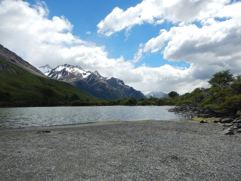
Lake mirroring the view of Fitz Roy
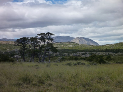
You probably arrive to El Chaltén from El Calafate, which has also a small airport. The journey takes about three hours and the rosd along the lake with a view of the majestic Fitz Roy tells you that there is a lot to see. During the afternoon you can still manage to reach the first campsite on the bank of Laguna Capri.
At the end of the town, leave the asphalt road and a wooden gate with invites you to the National Park. It is ess than six kilometers and four hundred meters of climbing to do. The trail climbs quite smoothly and when you look back you can see the wide valleyof Rio de Las Vueltas river.
We pass the crossing keeping left towards Laguna Capri. The campsite with reserved pitches is right on the shore of the lake. The majestic Fitz Roy is reflected in the surface of the Laguna Capri.


The Chilean-Argentine border passes right through the peak of Cerro Fitz Roy (3405 m). It is deviated some kilometers to the east in this place. The mountain is also called Cerro Chaltén, after the indigenous Tehuelche language, in which it means "smoking mountain". It is because of a cloud that regularly forms around its peak.
The omnipresent wind
Hiking to the next campsite is almost flat during the scenic four kilometers. Pass through a sparse forest and pass the turnoff to the marked Sendero Madre a Hija hiking trail, which we are going to follow the next day. At the end, cross the wide bed of the Rio Blanco stream over several wooden footbridges. Camp Poincenot is among the low trees.


You can easily continue uphill for another hour to Laguna de Los Tres. It is located a little higher (1160 m) and the wind from the icebergs is getting to be very strong here. On the opposite side of the lake, the Glaciar de Los Tres falls to the blue surface of the lake. Towards the south, more than a quarter of a kilometer below, the surface of another lake glistens. Laguna Sucia doesn't look dirty at all, as the spanish translation of its name might suggest. Cold water flows into it, leaving Laguna de Los Tres under our feet.
The return to the campsite is the same way.


Mother, Daughter and Tower
After less than a kilometer to the junction, turn right, towards the Agostini campsite. The Sendero Madre e Hija route is named after two lakes, which in translation mean mother and daughter. The smaller daughter follows after the longer mother. Both are surrounded by low trees and tall grass. Here and there you can approach a small gravel beach.
Descend through a twisted trees forest, reach the bed of the Rio Fitz Roy. Going down we would be heading back to El Chaltén. Hiking up, to the right, takes you through the valley, sometimes through tall reeds to the next viewpoint, which we just cannot miss.
Camping D'Agostini is hidden behind the natural dam of the Laguna Torre lake. When we climb a few meters up to its shore, an amazing view opens. We can see the lake, the glacier and the famous rock tower Cerro Torre (3128 m). The rock needle is one of the most challenging climbing destinations. Climatic conditions and the famous peak frost are the main reasons why this mountain is one of the most difficult in the world.


Back to El Chaltén
The Fitz Roy River starts from Laguna Torre and flows into the Rio de las Vueltas below El Chaltén. The marked route which we follow to return to the city is about ten kilometers long and runs along the left bank of the Rio Fitz Roy.
At first we still look back at the elegant Cerro Torre, later we pass through tall reeds until we reach the rocky canyon of the river. Soon we can see El Chaltém and with a bit of luck we still manage to catch a bus at the terminal at the outskirts of he city.


Comments