Silvretta Skitouring Weekend
- Mar 9
- 5 min read
It’s a bit of a drive—but well… it’s absolutely worth it. Perfect weather for spring sunbathing, and the snow in great condition. Simply a classic spring Jamtal. Jamtalhütte, Jamspitze, and then Dreiländerspitze.

03/2026
The name Silvretta has been associated with ski touring since, well, the age of dinosaurs. This mountain range, spread across roughly 900 square kilometres between Austria and Switzerland, is a renowned destination for ski mountaineering and glacier travel. The Austrian side consists of several valleys that can be linked into multi-day hut-to-hut traverses. Each hut also works perfectly as a base for lightweight day tours.
That’s exactly how Jamtalhütte (2165 m) operates. It is managed by the Swabian section of the German Alpine Club. Originally built in 1882 and reconstructed in 1999 after avalanche damage, the hut is fairly large. During the season, it accommodates up to 250 guests, and when closed, a winter room remains open. The complex also includes training facilities for mountain rescue teams and the Alpine Club in separate buildings. From the terrace, we have a clear view of most of the peaks we can aim for on day tours.

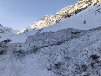


Access to the hut starts in the village of Galtür. Depending on road conditions, you can either park in the village or higher up. Whatever the car can’t reach, you cover on skins along the groomed supply road.
Just a Weekend Trip
We take it a bit fast this time. On Saturday morning, we step out of the car down in the village, as it’s currently impossible to drive any further. Well—maybe a little further would be possible, but the parking area is buried under snow, and once the frozen crust softens in the afternoon, we probably wouldn’t make it back.
We put our skis on right in the village, then take them off again, cross a few side streets, and from the upper junction onward we finally glide steadily uphill on skins.
Two weeks ago, after heavy snowfall, the avalanche map of the Alps was glowing red. Since then, things have calmed down again. In the valley, we cross several older avalanche deposits from side slopes. Some are barely visible now—just stripped branches and missing snow in the upper gullies. The groomer has already flattened most of it.
By late morning, we reach the hut, check in as a group of three, and leave some extra gear behind. Our sleeping bag liners must be placed in the microwave for twenty seconds—mandatory, right by the entrance. Supposedly, it’s an anti-flea measure adopted by all huts in the area over the past three years. Apparently, no fleas since then. I ask if there were any before.
“I don’t know, I’ve only been here three years,” the hut keeper replies.
Well, at least we don’t have to take off our ski boots and microwave our socks.


Two Jamspitze Peaks
Refreshed and lighter, we head out for today’s tour. Standing on the hut terrace, we look straight into the valley and see the twin peaks of Jamspitze right in front of us. To the right, in the foreground, rises the rocky Vordere Jamspitze (3176 m), a more demanding ascent. To the left, partially hidden behind it, is Hintere Jamspitze (3153 m), the more frequently climbed one—and we’ve all been there at least once.
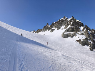
From the hut, we descend slightly to join a well-established skin track and gradually climb towards the Jamtalferner glacier. The direction is obvious, visibility is good, and the choice between several tracks sparks the usual debate about which one is better. Usually, it doesn’t matter. They all lead… well, not quite everywhere, but to the Jamjoch saddle (3065 m), where the increasing slope starts to remind us of the altitude—and the short night before.
We traverse below the east face of Vordere Jamspitze and from the saddle head left towards the summit. On skis, we climb as high as snow conditions allow—almost to the summit cross. With more snow, we wouldn’t need to take the skis off at all; later in spring, you’d leave them just above the saddle.
Time for a snack and views. The sun is shining, there’s no wind—it’s beautiful. On the opposite peak, we see a well-trodden track. We’re already pretty tired, but when it looks this good…
We drop back to the saddle and keep to the left, traversing as high as possible. It’s skiable almost all the way to the rocks; the final section is done in crampons.
In the steep slope, the snow is softening under the sun, and after a short climb, we start melting too. Soon we reach the summit ridge and walk the final few metres to the cross.
Back the same way—and then into the skis. A descent to the hut follows, along with a well-deserved dinner.


The Summit of Three Borders
On Sunday, we head for the highest and most popular peak usually climbed from Jamtalhütte. The name Dreiländerspitze (3197 m) reflects its location exactly on the tripoint of three regions. A metal plate at the summit cross marks the meeting point of the Austrian provinces of Tyrol and Vorarlberg with the Swiss canton of Graubünden.
From the hut, we start up the middle of the valley, then turn right under the rocky ridge of Vordere Jamspitze and continue up onto the glacier. The rocky summit rises directly above us, but the ascent is not as difficult as it appears from this angle. The summit ridge is still hidden from view.
First, we cross the Obere Ochsenscharte (2955 m)—essentially a perfect snack spot. This time, it’s easily manageable on skis.
From the saddle, a stunning view opens into the neighbouring Ochsental valley, dominated by Piz Buin (3312 m). Climbing it would mean descending almost all the way to Wiesbadener Hütte.
From Obere Ochsenscharte, we traverse roughly southward beneath a rocky ridge. I clearly remember not enjoying this icy traverse in the past, so I put on ski crampons right away—and later I’m glad I did.


We cross an old avalanche field and continue traversing in a steep north-west facing slope below the summit ridge. This is the point where we don’t rope up, but we leave our skis and continue on foot with crampons and an ice axe.
We move between rocks, occasionally stepping aside for others who had the same plan today—but are already on their way down. There are quite a few of them. Local guides have fixed ropes between occasional bolts.
Finally, the cherry on top: a short downclimb of about three metres, a brief traverse, and a final move up onto the summit block. The scraping of crampons on rock is drowned out by loud storytelling and jokes.
We’re on the summit. Beneath our feet is a round metal plate that vaguely resembles the logo of a certain unnamed car manufacturer. The inscriptions mark the borders meeting here—but the views are equally stunning in all directions.
We descend the same way and encounter a minor traffic jam at the end of the ridge while retrieving our skis. Then comes the descent—steeper at first, then more gentle all the way down towards the hut.
We left a few unnecessary items at the hut in the morning, so we have to climb a few extra metres from the valley floor to pick them up. After a quick snack, all that remains is the long descent down the valley.
Luckily, it runs well. There’s not much snow left, but enough to ski almost back to the car.
The sun is shining, and we almost don’t feel like leaving the parking area—but the drive home is long.


Lombok itineraries that include Rinjani National Park usually focus on duration options, but workload distribution across trekking days appears less examined. Compressed schedules could shift the perceived intensity of the journey. Certain external outlines present alternative pacing models, though the criteria behind those structures remain somewhat unclear.