Martinka route to Gerlachovský štít
- Sep 9, 2022
- 2 min read
Martin's route is one of the most classic And scenic ridge-routes in High Tatras, named after its first climber. Panoramic views from the rock towers are amazing.

09/ 2022
Gerlachovský štít (2654 m) Is the highest peak of Slovakia, High Tatras and the Carpathian Mountains. There are plenty of climbing routes. Touristic ones (UIAA II+ and easier) can be done only with a certified guide. From grade III can be ascended by organized climbers.
Martinovka (III) is the longest route and one od the most beautiful. From Polský Hrebeň pass (2200 m) the ridge stretches over towers and passes with various names. The most significant are Velický štít, Litvorový štít, Lavinový štít a Zadný Gerlach.


Starting point is Tatranská Polianka, where you can come by train or a car. From there it is two hours hiking to Hotel Sliezský dom by Velické lake. It is convenient to spend a night here. Hiking to Polský Hrebeň Is a pít two hours from the hotel.
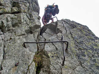
From Polský Hrebeň the real climb starts. The route follows the ridge, sometimes more on the left or right. The rock is pretty solid. From Velický štít, there Is a difficult slab to climb down, So it is safer to rappel down to the grassy ledge.


When we start climbing the weather is beautiful. Sunny day starts above the sea of white clouds rolling in the valley. As we continue climbing up, the clouds slowly reach us and cover all the mountain. It would ve nice to see more where we Are going. Zadný Gerlach is easy to recognize, because there is a metal box with summit book.


From here se climb some meters down to Gerlachovské sedlo pass (2590 m), where another climbers from different route come. The final ridge is easier than it seems to be and even more beautiful. Climb steep up from the pass and then a sharp exposed ridge to the summit cross. Finally we are here. The grey cloud covers all the panorama, but its warm and no rain is coming. Little break for a snack and we are ready to go down.
Descent via Batizovský žlab and Batizovská Próba is one of the easiest routes. It is also used as a touristic ascent route.


Steep scree gully with some rocks would be nicer in a better visibility. We are slowly getting bellow the cloud level and we still have a lot to go down. Lower part is narrow and very steep, but it is equipped with iron chains and steps. Once we get through this part it is just hiking. Soon we get to Batizovské lake and the touristic trail.
It is one more hour hiking to Sliezsky dom hotel. Here we meet other friend. Hiking back to the village takes about an hour and a half.


Comments