Hiking around Prague
- Aug 1, 2020
- 8 min read
Updated: Aug 7, 2021
Despite being a capital and the biggest city of Czech republic, Prague is a great base for hiking trips. There is an incredible variety of trails accessible by a less than one hour ride in public transport (trains or buses). Even within the city you can find many parks and natural areas with some marked hiking trails. How to use marked hiking trails is described here.
Especially south, southwest and southeast from the city, there is a nice hilly region with three rivers in valleys and forested surrounding hills. Vltava river is the main one coming to Prague from south Bohemia, flowing through all the city and ending north of Prague at Mělník in the confluence with Elbe (Labe) river. Others are Berounka coming from west and Sázava coming from east. All of them are surrounded by a variety of hiking trails abounding with beautiful views.
To taste the beauty of hiking around Prague, here are three tips you can experience. All of them require one day or less and can be easily done without a car. However checking a public transport timetable (www.idos.cz, also in english) in advance is very recommendable.
Red marked trail between Beroun and Karlštejn
This is a very nice tip for a day trip from Prague. Red marked trail is usually a long route and the described part is just one of the most beautiful. You can prolong it in both directions depending only on your wishes and condition. The route starts west of the city Beroun, right before the city going around a hill called Děd with a historical lookout tower.
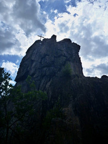
Beroun railway station is an easy starting point, because there is a frequent train connection from Prague. From there you follow red signs out of the city climbing gently in the forest and descending to a walley. After 4 km you arrive to a village called Svatý Ján pod Skalou with famous church and monastery. Under the church of St. John the Baptist, there is a cave of St. Ivan, who, according to a legend, lived there in 9th century. The spring at the side of the church bears the same name and was believed to have healing effects.
Above the monastery behind the church, you can see a rock with a cave and a cross on the top. The lookout definitely worth climbing as a side trip. A reward for the steep way up will be a beautiful panorama of the natural protected area of Czech Karst with white limestone rocks on the other side of the walley..
Back down at the monastery, follow the marked trail in direction of Karlštejn. Pass around the monastery wall, which is on your right. On your left, there is a nice limestone cliff bolted for sportsclimbing. The route turns left and climbs steeply to Propadlé vody. The name (something like disappeared waters) refers to the natural phenomenon of underground streams in karstic areas. From there, climb a bit more and descend to cross the road where the guidepost says Boubová. Continue on a wide forest road and then the trail descends through a beautiful valley downstream Bubovický potok (stream). This is a lovely place called Bubovické vodopády. It means waterfall, but don’t expect more than a small stream falling down a low rock step. During a dry summer, there might be just a wet and slippery rock with wooden railing to keep you safe.
Once you leave the forest, don’t continue down the valley. Turn left and after walking a bit up and down, you arrive to a huge tree called Dub sedmi bratří (Oak of seven brothers). From this landmark, it is just a few steps to join the asphalted road, cross it and after a while climb to the Karlštejn castle.
Karlštejn is one of the most famous Czech castles, so don’t miss the visit. Being hungry after the hike and satisfied with historical site, the time for a lunch comes. In the village below castle, there is a great variety of restaurants.
If these 13 km were enough, you can just do one more to the train station and return to Prague. If you wish more hiking, there is nothing easier than continue following the red trail almost to Prague. There are more options where to descend to the valley of Berounka river and catch a train.


Posázavská stezka - Sázava river trail
Easy short (11km) trip from Prague follows red marked trail along the Sázava river valley. Sázava is one of two rivers which join Vltava before it comes to Prague. Sázava comes from the east and ends in Vltava in Davle village. Sometimes the confluence is interesting to see from the road bridge just below the junction. Especially after rainy days, Sázava brings brown muddy water from nearby rapids while Vltava remains dark with a sharp line in between. It takes few hundreds meters to dissolve.
The wild part of Sázava, besides being a perfect place for enjoying an easy canoe adventure, is followed by a nice red marked trail called Posázavská stezka (Sázava trail). It is one of the most traditional hiking destinations easily reached by a 45 mins train ride from Prague. Due to its close location and natural beauty it used to be one of the first locations where people from Prague started to make their simple weekend country houses seeking for some romance and escape from the daily city life.
The best option is to take a train to Kamenný přívoz station and walk downstream to Pikovice. The train comes from Prague along the right riverbank of Vltava and then Sázava. From the window you will see the deep river valley you are about to explore hiking. Without seeing it, you cross the highest stone bridge in the country. Later you can admire this 40 m high historical masterpiece hiking on the other side of the river. This arch railway bridge was constructed at the end of 19th century by italian workers.
At the Kamenný přívoz train station you will find tourist signpost. Follow red trail downwards to the Kamenný Přívoz village, where you cross the bridge over Sázava river. Now, on the left bank keep following red marking. At first it climbs a bit on the asphalted road which turns left. Then the route leaves the road and follows the beautiful deep Sázava valley. The navigation is easy, just keep following red signs and enjoy breathtaking views at the river below.
The route is not much hilly, but it climbs and descends sometimes and some parts are a bit steep. There are several stony steps along the trail. When you see the Žampach stone bridge, mentioned above, you are approximately in one third of the way. From other viewpoints, you can see river rapids and in summer most likely also paddlers enjoying a canoe trip.
At the last part across the river you will see a significant rock tower with a cross on top. It is called Pikovická jehla (Pikovice needle). Soon after some small weekend houses start to appear, the forest ends and after crossing a wide meadow, you reach the final point, Pikovice. You can have some simple sweet snack and coffee in the small house close to the bridge. To get a big meal, find a restaurant following the road up from the river.
Train station is on the other side of the river. It is called Petrov u Prahy after the village lying above. If you want to continue hiking, Davle is a good option. It is the next stop of the same train and there is also a bus station.
If you want to make your trip much longer, start higher upstream in Týnec nad Sázavou train station. Blue marked path (direction Holý vrch) brings you to the red one which you would follow through Dolní Požáry, Horní Požáry and Prosečnice. The distance almost doubles to 21 km and it is more hilly.


Štěchovice - Svatojánské proudy
South of Prague, there is an inexhaustible choice of hikes. The valley of Vltava river offers so many possibilities of both short and long trips in a hilly landscape. Buses of Prague Integrated Transport Prague (wider public transport network around Prague city public transport) takes you to Štěchovice. From Smíchovské nádraží (Smíchov railway station) you need less than 40 mins to get there.
Štěchovice is a small town lying on the Vltava river southern from Prague. When you get out of the bus, you will see a touristic guidepost named Štěchovice. From there, educational path called Svatojánské proudy (St. Jonhs rapids) starts. The name reminds old times before Štěchovice and Slapy dams vere built. There is also a blue marked trail in direction Nad Přehradou (Above the dam). The name gives a hint, what are you going to see next. Following these signs along the left bank of the river to the end of the city, you will see the structure of Štěchovice dam. It is a part of Vltava Cascade - system of dams along the whole river regulating its stream.
There is also a possibility to arrange a visit at the water power plant. The reservoir above the dam is also used by the pumped-storage hydroelectric plant Štěchovice II whose upper reservoir is located on the top of hill Homole on you right.
Soon after entering the forest, the path crosses two huge water tubes connecting the power plant and the upper reservoir. At the signpost Nad Přehradou the blue trail leaves the river bank and climbs to the right. This is an option to see the upper reservoir. You continue following educational trail together with a green trail. Sometimes a bit rocky path winds along the deep river valley. There is also a short tunnel in the rock to make your way easier.
At the end of the trail, there are some huts and after about 9 km you face another dam. This one is called Slapy. Its lake is a famous summer recreational destination. Below the structure, there is a memorial statue of St. John. Touristic trail climbs up the stairs on your right. After passing a big parking on your left, there is a bus stop (called Třebenice) just in front of you on the main road. There is also a small grocery shop.
Few hundred meters left on the asphalt are worth to get to the road on the top of the dam structure. The view on both sides is beautiful. There is also a small recreational boats harbour on the upper lake. There is no lock chamber on this dam. All the boats needing to pass this barrier has to be transported by a tractor with a trailer, so there is a size limitation.
If you don’t want to end your trip here, there is an option to make a loop back to Štěchovice. The hike at the other side of the river with several breathtaking views will be about 25 km in total. From Třebenice, the blue trail crosses the dam and continues on the road through Rabyně village. Than it turns to the left on a forest path till the crossroad named Pexův luh. From here, take a yellow trail for a long time climbing up and down side valleys.
First village you meet is called Teletín. After this village, there is a nice 0,5 km side trip to a beautiful lookout. It is called Vyhlídka Máj (may) and is not included in the marked trail. Usually there is an additional sign, or you can check the location on www.mapy.cz. Another beautiful lookout is called Smetanova vyhlídka, which is a marked side trip. Just after enjoying that beautiful place, the trail crosses a main road and comes to Třebsín village. From there a blue trail brings you back down to the Vltava river, where you cross the bridge. While waiting for the bus, you can enjoy a sweet snack in a coffee in front of the bridge.


Comments